A driveway every one hundred and fifty feet, on every county road, all at once.
That is the practical effect of the Jo Daviess County zoning amendment on the table this spring — a wholesale cut in the rural minimum lot size from forty acres to one, paired with a 150-foot frontage requirement per parcel. By the time it is built out, it is also the rule that forecloses any future of low-speed-vehicle corridors, multimodal trails, and shared-use roads across the Driftless.
There is a better draft. This site is the working version.
The Apple River is gold in the dusk. Along Main Street, sidewalk tables are full — a couple from Elizabeth who took the LSV trail in for dinner, a family that stabled their horses at the corridor terminal an hour ago, two graduate students who biked down from Stockton.
None of this exists yet. It is allowed, or disallowed, by decisions being made right now in a Jo Daviess County board room — beginning with whether to permit subdivision down to one acre, and whether to do it on purpose or by accident.
This site is an argument that on purpose is the choice worth making, and a working draft of what that purpose would have to be.
Where this stands in Jo Daviess.
§ 00The amendment in plain terms.
Drop the Ag-1 minimum lot size from 40 acres to 1. Require 150 feet of road frontage per parcel. That is a 40-fold increase in permitted density across every unincorporated acre in Jo Daviess County, and it is the rule that determines whether any of the seven county roads in the proposed corridor network can ever be safely shared with cyclists and low-speed vehicles.
What the City of Galena has said.
A letter to the County co-signed by Mayor Terry Renner, City Administrator Matthew Oldenburg, Zoning Administrator Jonathan Miller, and City Attorney Joseph Knack puts the city formally on record opposing the amendment. The letter projects the cost of community services would move from $1.02 to $2.11 per dollar of property tax revenue generated — fiscally distressed territory by any standard methodology — and names aquifer and septic risks in the coulees as substantive grounds on their own.
What this site argues.
The argument is not vote no. It is vote no on this version, and direct staff to bring back a draft built on Conservation Subdivision Design — clustered lots, consolidated access points keyed to corridor planning, and a sliding-scale minimum lot size that responds to slope, soil depth, and aquifer sensitivity rather than a single flat number.
That is a defensible policy package. It gives the development-rights constituency a path to subdivide. It gives the conservation and safety constituency the protections they need. And it preserves the corridor future this site proposes for all seven counties.
What defines an LSV community.
§ 01or 2 hours by horse
An LSV community is anywhere two village centers sit within twenty minutes of each other at the lawful top speed of a low-speed vehicle. That is roughly eight miles — about the distance from Hanover to Elizabeth, from Mt. Carroll to Lanark, from Stockton to Warren.
The unit of planning is not the parcel. It is the corridor between two places people already live, and the question of what one can reasonably do along its length.
What the end looks like.
§ 02A vibrant village with a walkable downtown.
Cars exist; they are not the protagonist. Parking moves out of sight. Sidewalks widen. The river or the trail is the front of the building, not the back.
Sidewalk dining and pedestrian priority.
Along river fronts and trail edges, the street belongs first to people on foot — then to bikes and LSVs — then to vehicles passing through. Each town keeps its own character; no two downtowns are interchangeable.
Equestrian hubs within view.
Horses are stabled at the edge of the village, near the trail terminal, with water, shade, manure management, and trailer parking — visible from the downtown, not hidden in a back lot.
Evening hours that mean something.
Dining, music, shopping, and lodging that reflect the character of each town — Hanover is not Galena, Stockton is not Mt. Morris, and the plan does not pretend otherwise.
Seven counties, one corridor logic.
§ 03The Hanover–Elizabeth corridor in Jo Daviess County is the pilot. The same template applies, with local variations, across the six counties to the east. Each county page is the place to argue about what the local version should be.
What people are asking.
§ 04A plan that does not take its critics seriously is a plan that will fail at the county-board level. Each county page surfaces these questions in local form; here are the seven we keep hearing.
If my neighbor sells to a developer, do I get a row of houses across my fenceline complaining about manure and dust?
Whatever you call this, does it protect what my land is worth — or limit my options?
Galena is unaffordable and the city is far. Is there somewhere within reach where we could actually live?
Who pays for the roads, septic, EMS, and school buses to scattered parcels — and what's the alternative?
This is Driftless karst. Groundwater is fragile. How does this proposal protect what scattered subdivision would not?
If you mean it about corridors, what are the actual standards for surfacing, parking, water, and stabling at the terminals?
Our building has held this community for a hundred and forty years. What is the village without it — and what is the building without us?
Where the conversation continues.
§ 05Talk to Lester.
A tailored survey for landowners, board members, neighbors, and visitors — hosted on the Driftless Rivers project site.
DriftlessRivers.us → Companion projectSave Rural Churches.
You cannot have a vibrant village without the buildings that built the village. A companion effort to revitalize the historic congregations whose buildings still anchor these towns.
SaveRuralChurches.org →The vision, in four exhibits.
§ 06The four pages below are the working visual handouts for this project — the same materials being circulated at township halls, county board meetings, and over coffee in Galena, Hanover, and Elizabeth. They are drafts. Argue with them.
Zoning for Vibrant Villages — the opportunity zones.
Exhibit 01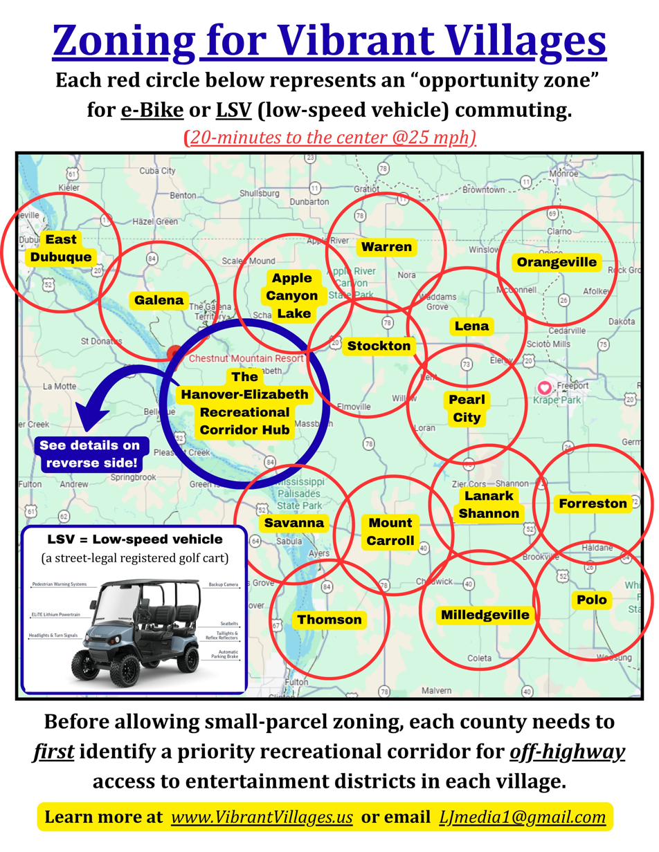
The Hanover–Elizabeth Recreational Corridor Hub.
Exhibit 02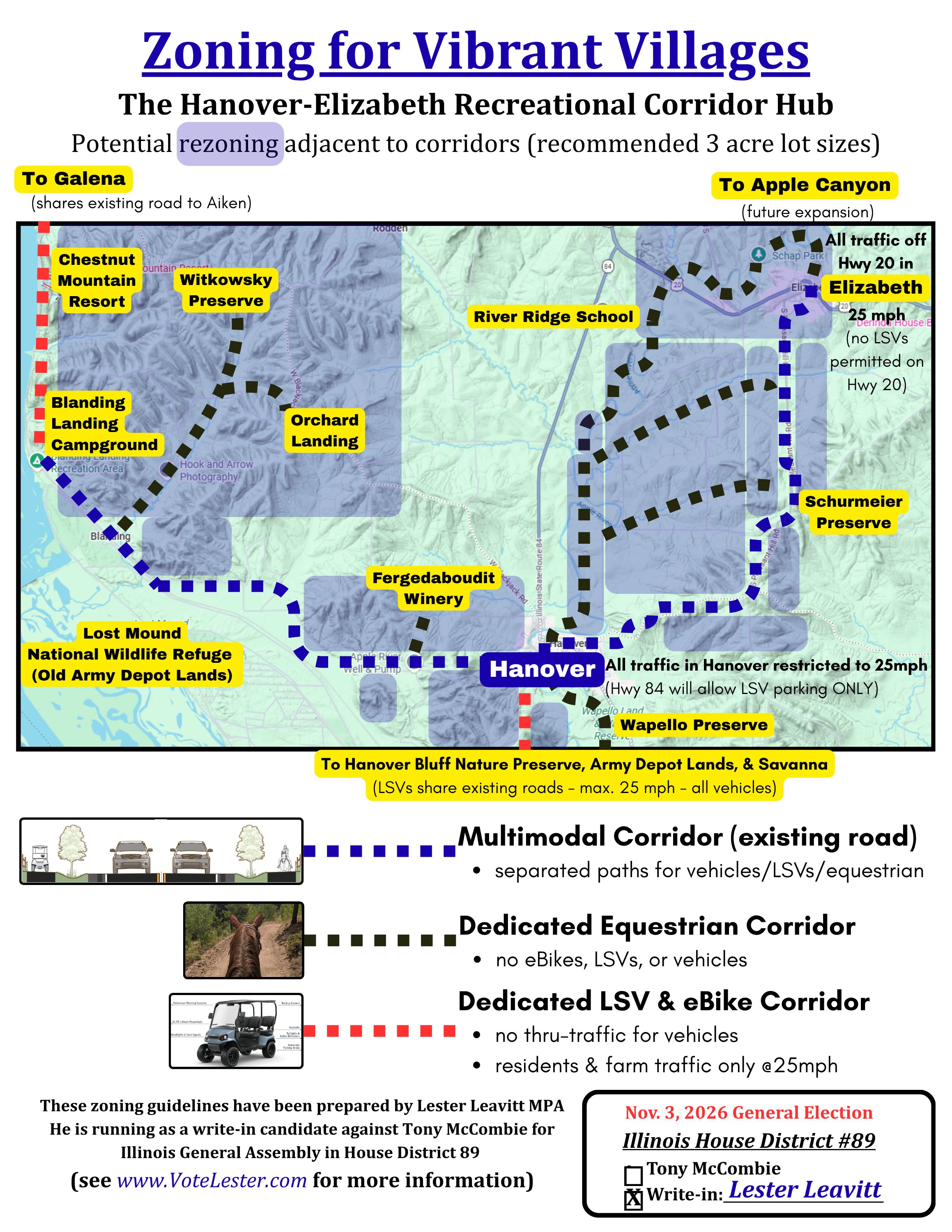
Suggested LSV Corridors for Galena.
Exhibit 03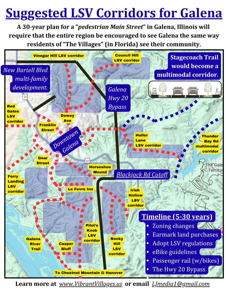
The Steps to Success.
Exhibit 04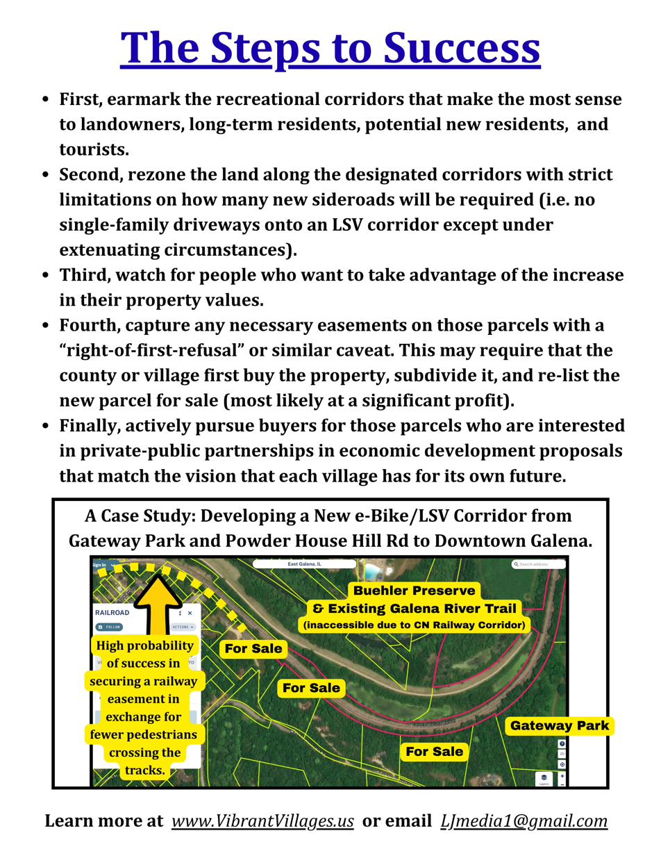
These exhibits are the work of Lester Leavitt, MPA, on behalf of Driftless Rivers Coalition, Inc. They are excerpted from the working document Jo Daviess County 2076 — Vibrant Village Centers for the Third Century, available on request through the contact form at DriftlessRivers.us.